
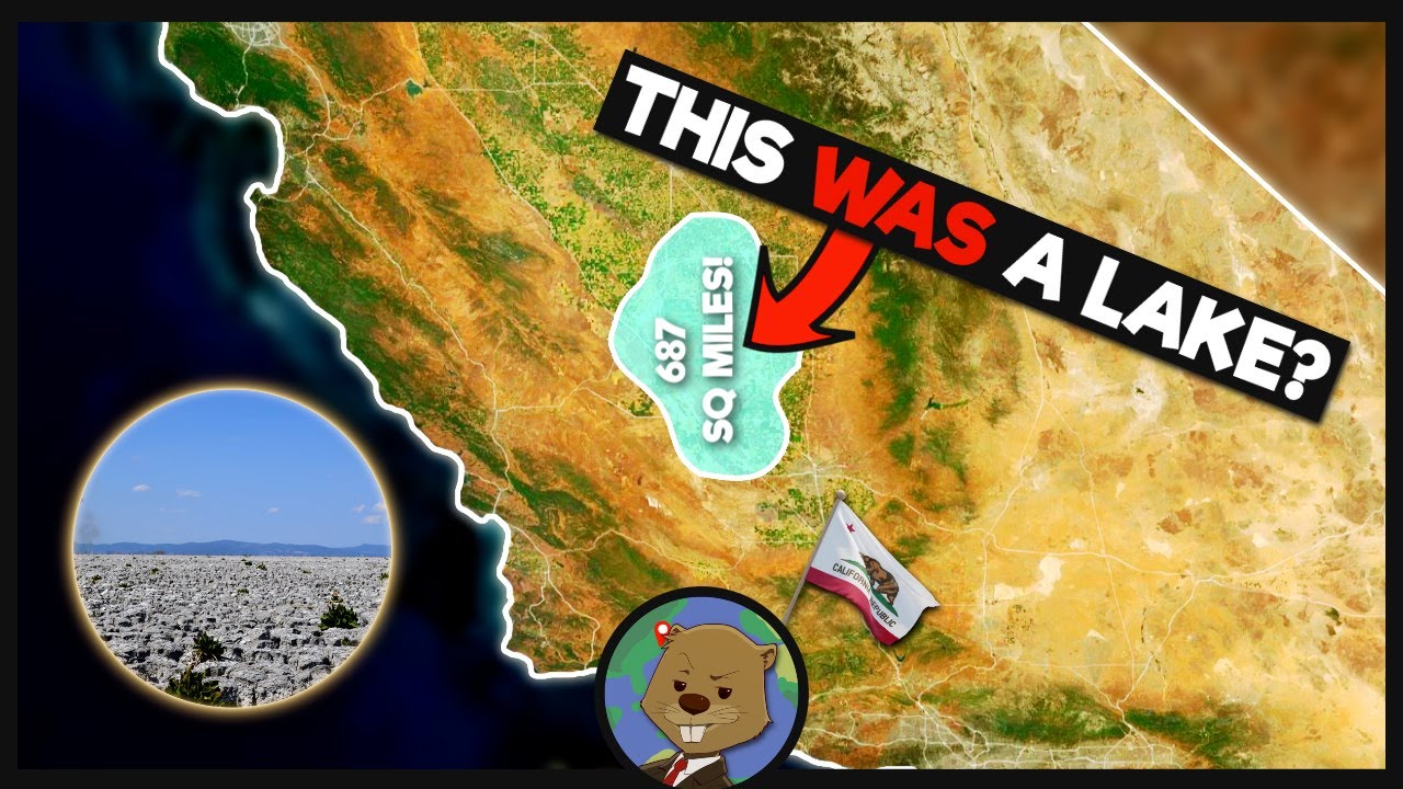
After more than a century of absence, California’s historic Tulare Lake has reappeared, drawing attention from scientists, government agencies, and residents across the San Joaquin Valley. Once recognized as the largest freshwater lake west of the Mississippi River, Tulare Lake returned during 2023 following extreme weather conditions that exceeded the capacity of modern water-control systems.
The reappearance was neither brief nor symbolic. Water spread across vast portions of the former lakebed, inundating farmland, disrupting transportation routes, and forcing emergency actions. The event highlighted how natural landscapes can reassert themselves even after decades of human modification and development.
Table of Contents
Historical Background of Tulare Lake

Historically, Tulare Lake occupied a shallow, closed basin in central California, meaning water flowing into it had no natural exit to the ocean. Seasonal snowmelt from the Sierra Nevada mountains fed the lake through multiple rivers, causing its size to fluctuate significantly from year to year depending on rainfall and temperature patterns.
By the late 19th century, large-scale agricultural expansion transformed the region. Rivers were diverted, levees were built, and wetlands were drained to support farming. These changes gradually eliminated the lake from the surface, though the basin itself remained intact beneath cultivated land.
Weather Conditions Behind the Lake’s Return

The winter of 2022–2023 was one of the wettest in California’s recent history. A series of intense atmospheric river storms delivered prolonged rainfall across the state, while the Sierra Nevada accumulated an unusually deep snowpack, far above long-term seasonal averages.
When spring arrived, rising temperatures caused rapid snowmelt. Rivers and canals that usually manage runoff were overwhelmed, and excess water followed the natural topography into the historic Tulare Lake basin, where it collected and spread.
Scale and Visibility of the Reemergence
The return of Tulare Lake was documented using satellite imagery and aerial surveys, which confirmed the extent of flooding across the valley floor. What had previously been farmland quickly transformed into a large, shallow body of water visible from space.

Because the basin lacks natural drainage, water levels declined slowly. In several areas, standing water remained for months, increasing damage to crops and infrastructure and extending recovery timelines for local communities.
Historical and Modern Data
| Category | Details |
|---|---|
| Historical status | Largest freshwater lake west of the Mississippi |
| Period of disappearance | Late 1800s to early 1900s |
| Reason for disappearance | River diversion and agricultural expansion |
| Year of major return | 2023 |
| Estimated flooded area | Over 100,000 acres at peak (estimates vary) |
Impact on Agriculture and Communities
Agriculture was among the sectors most affected by the lake’s return. Farmers suffered substantial financial losses as the lake submerged thousands of acres of crops, including cotton, alfalfa, tomatoes, and nut orchards, during critical growing periods.
Communities built on low-lying land also faced challenges. Evacuations were ordered in some areas, roads were closed, and aging infrastructure required emergency reinforcement. The flooding highlighted long-standing vulnerabilities in regions developed on former lakebeds.
Environmental Effects of the Reappearance
From an ecological perspective, the reappearance of Tulare Lake temporarily restored wetland conditions that had been absent for generations. Migratory birds quickly returned, using the lake as a stopover along major migration routes.
However, environmental concerns accompanied these benefits. Floodwaters flowed across fertilized fields and livestock areas, raising concerns about nutrient runoff, contamination, and the long-term effects on soil quality once the waters receded.
Main Drivers Behind the Event
A single factor did not cause the return of Tulare Lake. Instead, it resulted from the interaction between extreme weather conditions and long-term landscape changes.
Primary Factors
- Exceptional rainfall combined with record Sierra Nevada snowmelt during the same season
- Decades of river diversion and land development have significantly changed the geography of the closed basin.
Government and Emergency Response
As water levels rose, state and local agencies activated emergency response plans. Measures included reinforcing levees, managing controlled water diversions, and issuing public safety advisories to affected communities.
Satellite data and flood modeling tools were widely used to track water movement and assess risks. Damage assessments were launched to support disaster relief efforts and guide long-term recovery planning.
Impacts and Official Responses
| Area | Observed Impact | Response Actions |
|---|---|---|
| Agriculture | Widespread crop losses | Damage assessments and aid planning |
| Communities | Evacuations and road closures | Emergency shelters and safety measures |
| Environment | Temporary wetland restoration | Wildlife and water-quality monitoring |
| Data & planning | Rapid water spread | Satellite mapping and flood forecasting |
What the Return Means Going Forward
Scientists emphasize that Tulare Lake never truly disappeared; only the water did. The basin remained part of the natural landscape, and extreme weather conditions enabled water to resume its historical course.
As climate variability increases, officials are reassessing flood management strategies, land use policies, and whether parts of the basin could be intentionally used for seasonal water storage or groundwater recharge in the future.
What to Watch Next
Attention now turns to long-term recovery and preparedness. The event has prompted renewed discussion about how communities and agricultural systems can adapt to increasingly variable weather patterns.
Next Developments
- Ongoing monitoring of water levels, soil conditions, and infrastructure recovery
- Policy discussions focused on flood resilience, land management, and climate adaptation.
The sudden return of Tulare Lake after 130 years serves as a clear reminder that historical geography continues to shape modern outcomes, even after generations of human intervention.
Sounds to me like someone or rather lots of someone's weren't paying attention before they started building.
Yeah maybe 🤔they should have.